Backroad Maps
Backroad Maps Alberta GPS Garmin Maps
Couldn't load pickup availability
-
Craze Outdoors Advantage
- 5 - Star Google Reviews
- Free Shipping Over $100
- Same day shipping
- 30 Day Price Match
- Easy 30 Day Returns
Alberta GPS Maps (Garmin) – Advanced Backcountry Navigation System
Take your navigation off the grid with the Backroad Mapbooks Alberta GPS Maps—a powerful, Garmin-compatible mapping system designed for serious backcountry exploration, trip planning, and real-time navigation. Built with the same trusted data as Backroad Mapbooks, this digital solution delivers unmatched detail and reliability across Alberta’s diverse landscapes.
Preloaded on a plug-and-play microSD card, these maps bring together topographic mapping, routable roads, trail systems, and thousands of recreation points of interest—so you can confidently explore without relying on cell service.
From Peaks to Plains
Alberta is a land as diverse as it is beautiful, flanked by some of the world’s tallest and most iconic mountains on one side and the sprawling Canadian prairies on the other. Below the famous Rockies, the foothills contain endless opportunities for camping, fishing, ATVing and more. As you move north, the wilderness becomes more pronounced and forest and muskeg dominate the landscape. To the south, the grasslands and farmer’s fields reflect the province’s rich ranching and agricultural heritage. And wildlife is found in abundance throughout the province, from grizzly bear to snowy owl and pronghorn antelope.
Alberta Backroad GPS at a Glance
Designed for industry use and outdoor recreationists, this product combines all of Alberta into one Backroad GPS Map, including our Southern Alberta, Central Alberta and Northern Alberta Backroad Mapbook titles.
Over 410,000 km of our backroads network combined into one map, including close to 320,000 km of routable roads.
Searchable Oil and Gas LSD Grid Locations, Compressor Stations, Gas Plants, Wellsites and other Resource Facilities.
Address and Township & Range Search for easier than ever navigation.
Lake Bathymetry depth contour for over 150 fishing lakes, rivers, and streams.
Marked Wildlife Management Units (WMUs) for hunters.
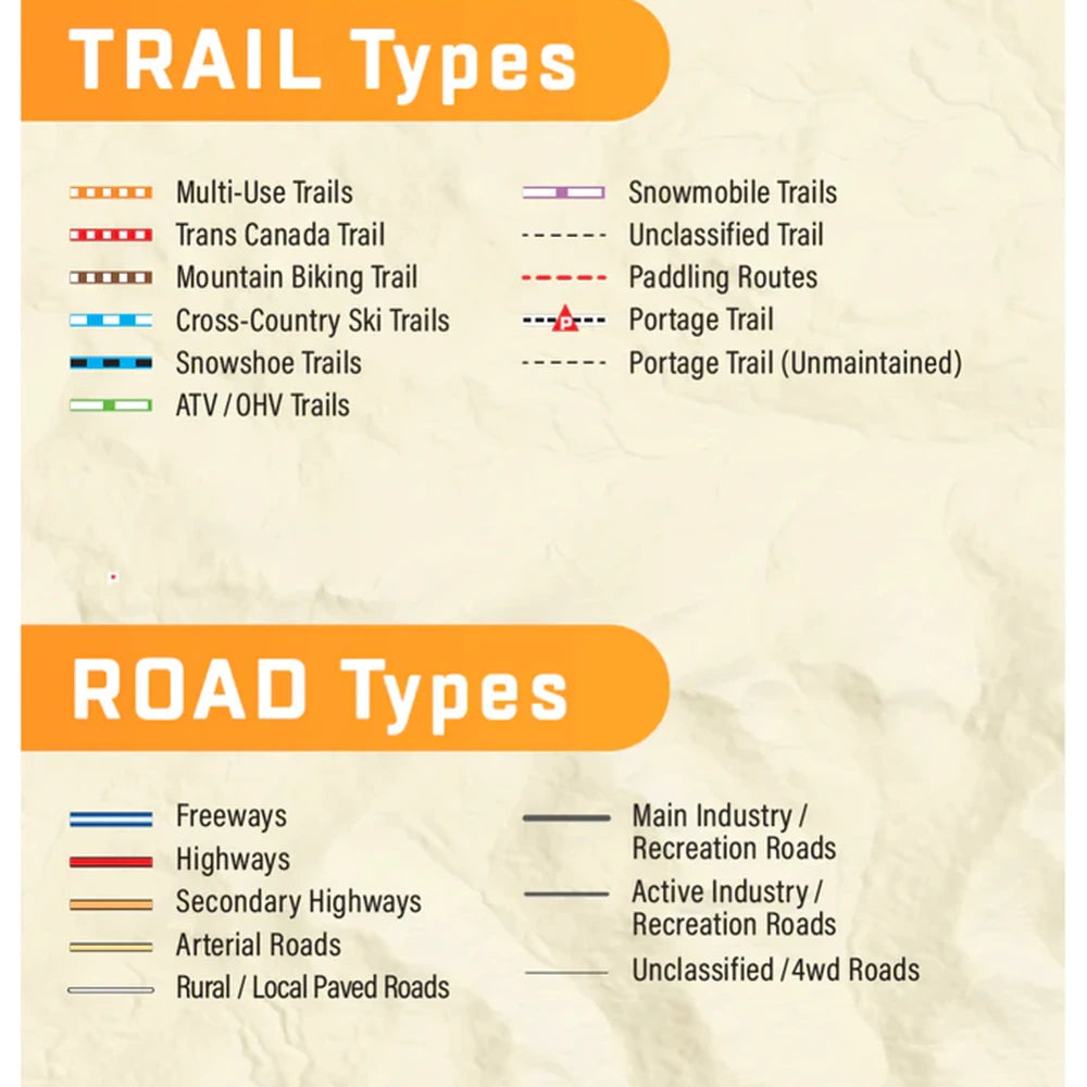
Tens of thousands of kilometres of multi-use hiking, biking and cross-country skiing trails and paddling routes, with marked trailheads and access points/portages.
Over 2,800 km of new ATV and snowmobile trails in Version 2019.
Thousands of fishing hotspots, parks and conservation areas, campsites, hunting areas, winter recreation areas and more.
Over 16,000 land and water geographic features.
Enhanced cartography for improved display of parks, conservation areas, Crown land, creeks and activity Points of Interest.
Improved snowmobile route lines, First Nations reserve coverage and railway corridor mile markers.
Navigate Alberta Without Limits
When your adventures take you beyond cell service, the Alberta GPS Maps deliver the precision, detail, and reliability you need to explore confidently—anywhere in the province.
Features
Features
Built for Real Alberta Exploration
Designed for both recreation and professional use, these GPS maps are trusted by outdoor enthusiasts, industry users, and search-and-rescue teams.
They include:
1,900+ trails (hiking, ATV, snowmobile)
1,400+ fishing lakes and rivers with species data
800+ paddling access points and routes
1,900+ parks and recreation areas
320,000+ km of roads (routable and non-routable)
From the Rocky Mountains to the prairies, this system gives you the confidence to explore anywhere in Alberta with precise, real-time positioning.
So Much More Than Just Maps!
Backroad Mapbooks’ industry-leading, Garmin-licensed Alberta GPS Maps are the most detailed, comprehensive and up-to-date GPS maps available on the market. These are the maps of choice for recreation, industry, and search-and-rescue, with 3D views, shaded relief and countless geographic and activity based points-of-interest. Updated annually, these GPS maps are Garmin licensed for compatibility with Garmin GPS and Garmin Basecamp. Available in Micro SD format, these Alberta GPS Maps are easy to install and use and bring you all of the detail of our wildly popular Backroad Mapbook series directly to your GPS device or computer. Keep your adventure rolling with the latest topographic data, routable roads, oil and gas data, Wildlife Management Units, trails, rec sites, paddling routes, scenic viewpoints and so much more. With the latest edition of our Alberta GPS Maps in hand, your options for adventure are limitless.
Alberta Backroad GPS Map Features
Garmin-licensed & compatible with Garmin GPS™, Basecamp™, MapSource™ and RoadTrip™.
Includes all standard Garmin features such as the Find tool, city navigation and more.
Includes a Free One-Year Pro Subscription to the BRMB Maps smartphone App and Web Map.
Preloaded 1:20,000 / 1:50,000 base scale seamless topographic maps.
Provides 3D views and the highest level of map detail available on select Garmin GPS units and Basecamp™.
Compatible with the brand new Garmin 66i unit and inReach technology.
The most complete Resource, Industry, and Logging road coverage available for Alberta
Extensive routable road network including City, Resource, and Industry Roads.
Highlights tens of thousands of kilometres of trail systems, including defined ATV, Paddling, Snowmobile, Long distance & Multi-use trails.
Features smart background & Searchable Wildlife Management Units (WMUs) for hunters.
Includes National, Provincial, Regional, and other Parks & Campsites.
Extras like Lake & Stream Fishing information with boat launches, paddling access points, bathymetric depths, and more.
Searchable BRMB descriptions and activity information for fishing, paddling, parks, trails and more.
Thousands of Searchable cities, Geographic Land, and Water features.
Includes Oil and Gas LSD Grid Locations, Compressor Stations, Gas Plants, Wellsites and other Resource Facilities.
Industry leading cartographic contours and shaded relief for all of Alberta.
Features Address and Township & Range searching to aid navigation.
And much more!
Why You'll Love This
Industry-Leading Detail – One of the most comprehensive GPS map systems available for Alberta.
Garmin-Compatible – Works with Garmin GPS devices, Basecamp™, and MapSource.
High-Resolution Topographic Mapping – 1:20,000–1:50,000 scale detail with shaded relief.
Extensive Routable Road Network – Includes highways, forestry roas, and industrial access routes
Massive Recreation Database – Thousands of trails, campsites, lakes, and outdoor locations.
3D Mapping & Navigation Tools – Enhanced terrain visualization on supported devices.
Annual Updates – Keeps data current for evolving roads, trails, and access points.
Specifications
Specifications
PLUG & PLAY MicroSD Card:
Plug & Play Installation: Simply insert the card into your Garmin GPS unit, and you're ready to go!
Card Size: Pre Programmed on 8, 16 or 32GB microSD card. Our GPS maps occupy up to 2GB of space on the SD card.
Coverage: Single Province or Pre Built Combo Maps
SD Card Adapter: The maps are stored on a microSD card. The packaging includes an SD card adapter for older units.
DIGITAL LICENSE
Immediate Installation: After your purchase, you can download the maps and install them on your device right away using Garmin Basecamp. No shipping required.
Coverage: Customizable Maps, Build and combine maps the way you need.
Compatible with Garmin Smartwatches: Install maps on your new Fenix, Descent, MARQ, or other Garmin smartwatches. Check the list for compatible models.
Point of Interest (POI)
Unique to BRMB’s Alberta GPS Maps are feature POI sets of over 5 million searchable points including Oil and Gas LSD Grid locations, Compressor Stations, Gas Plants, Wellsites, other Resource Facilities and Backroad POI sets.
Note: Backroad POIs can be searched by selecting the Where To/Find > Extras and then Go! option, or read what each site offers through the More option.
Oil and Gas Resource Facilities can be searched by selecting Where To/Find > Cities and then by entering the full Grid reference for Facilities. For Alberta facilities enter the full LSD Grid Reference (ex: 6-14-36-20-W4).
Scale: Dynamic Scale
Version: V2025
Covering Southern Alberta, Central Alberta, Northern Alberta, & Canadian Rockies Regions these GPS Maps are the most detailed, comprehensive and up-to-date GPS maps available on the market.
Keep your adventure rolling with the latest topographic data, routable roads, oil and gas data, Wildlife Management Units, trails, rec sites, paddling routes, scenic viewpoints and so much more. With the latest edition of our Alberta GPS Maps GPS Maps in hand, your options for adventure are limitless.
Alberta Custom POI Highlights
Over 5.3 million searchable Oil and Gas LSD Grid locations
Over 5,000 Compressor Stations
Close to 700 Gas Plants
Over 30,000 Resource Facilities
Over 43,000 Wellsites
Close to 200 Wildlife Management Units (WMU) for hunters
Fishing Lakes and Rivers with over 1,400 locations with descriptions and fish species
Over 260 Boat Launch locations
Over 1,900 Trails with front country and backcountry locations and descriptions
ATV Trails with close to 300 trailhead locations and descriptions
Snowmobile Trails with over 240 trailhead locations and descriptions
Parks with over 1,900 National, Provincial and Regional Park locations and descriptions
Recreation Areas with over 230 locations and descriptions
Over 420 Backcountry campsites
Over 700 Campground and Picnic locations
Paddling with close to 800 paddling route access points descriptions and portage locations
Wildlife Viewing with 400 locations and descriptions
Over 300 Winter Recreation Sites and Downhill Ski Areas
Close to 2,500 City, Town and Community locations
Over 16,000 searchable land and water geographic features
110 Backcountry Huts and Cabins
Alberta Categories:
Backroad Attractions
ATV-OHV Trails
Backcountry Camps
Boat Launches
Border Monuments
Campsites
Cities
Compressor Stations (found under city search)
Fishing Lakes, Rivers, Streams
Gas Plants (found under city search)
Gates
Golf Courses
Hot Springs
Hunting Areas
Huts
Land Features
Lodging
Oil and Gas LSD Grid Locations (found under city search)
Marinas
Paddling Access
Paddling Routes
Parks – Provincial – National - Urban
Picnic Areas
Portage Locations
Public Services
Recreation Areas
Resource Facilities (found under city search)
Restaurants Rivers and Creeks
Ski Areas
Snowmobile Routes
Trails
Transportation Services
Visitor Information
Water Features
Waterfalls
Wellsites (found under city search)
Wildlife Viewing
Winter Recreation
Share
We clean up after ourselves.
Ecommerce deliveries have a carbon footprint. That's why we support verified projects that remove carbon from the air.
Every delivery’s carbon footprint is calculated based on weight, shipping method, and distance traveled. We neutralize these emissions by purchasing verified carbon removal credits from groundbreaking projects.
With your purchase, you’ll join a community of proactive merchants and customers dedicated to a sustainable future. Together, we've removed emissions for over 80 million deliveries and removed over 56 thousand tonnes of carbon.
We work with a network of pioneering carbon removal companies that have been vetted by the commerce platform Shopify.

