Skip to product information
1 of 5

Backroad Maps

Backroad Maps Kakwa Provincial Parks – Alberta & BC Park Recreation Map

Backroad Maps Kakwa Provincial Parks – Alberta & BC Park Recreation Map

Regular price $29.95 CAD
Regular price Sale price $29.95 CAD
Sale Sold out
Shipping calculated at checkout.

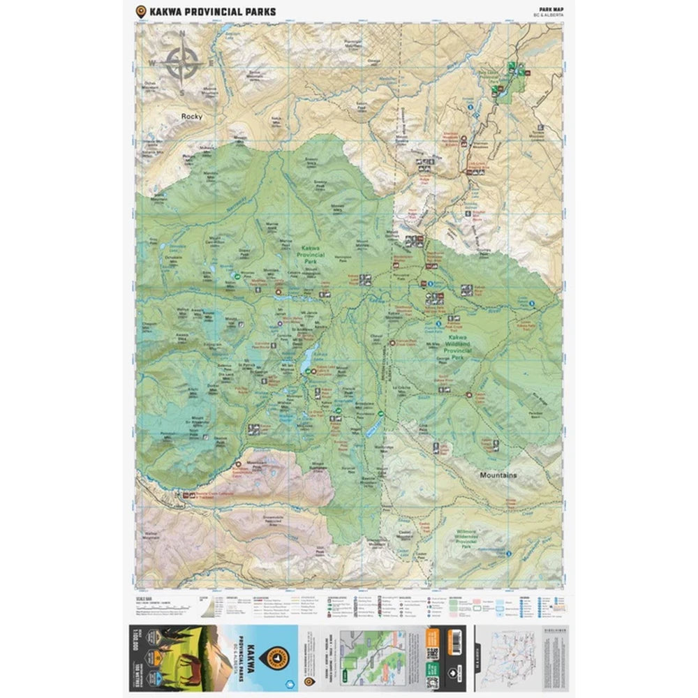
Kakwa Provincial Parks (Alberta & BC) – Park Recreation Map

Explore one of Western Canada’s most remote and rugged wilderness regions with the Kakwa Provincial Parks – Alberta & BC Park Recreation Map—a high-detail, field-ready map designed for serious backcountry navigation and adventure planning. Covering both Kakwa Wildland Provincial Park (Alberta) and Kakwa Provincial Park & Protected Area (BC), this map delivers unmatched clarity for exploring this vast interprovincial wilderness.

Built with industry-leading cartography and large-scale detail, it provides everything you need to confidently navigate remote terrain—from access roads and trails to campsites and recreation points.

Perfect For

Backpacking • Hunting • Fishing • Overlanding • ATVing • Paddling • Expedition Planning

Navigate Remote Terrain with Confidence

For one of Canada’s most rugged and remote backcountry regions, the Kakwa Provincial Parks Recreation Map is an essential tool—delivering the precision, durability, and detail needed for true off-grid exploration.

Features

Covering Kakwa Wildland Provincial Park in Alberta and Kakwa Provincial Park and Protected Area in BC, this topographic recreation map shows you all the access roads, trails for hiking, mountain biking, horseback riding, snowshoeing, cross-country skiing, ATVing and snowmobiling, backcountry huts and cabins, fishing lakes and rivers, waterfalls, viewpoints, recreation sites, campgrounds, backcountry campsites and more! Using 1:10,000 & 1:20,000 scale data, this map features our industry-leading topographic contours and relief shading, giving you more detail than any other map for this area. Included on the map are Kakwa Falls, Kakwa Lake, Broadview Lake, Cecilia Lake, Corniche Pass, Deadhorse Meadows, Francis Peak, Jarvis Lakes, McGregor River, Moonias Pass, Mount Ian Monroe, Mount Ruth, Narraway River, Sulfur Ridge, Torrens River, Trench Creek, Two Lakes, Walker Creek Forest Service Road and more!


The printed version of the map is displayed at 1:100,000 scale on 61 x 94 cm (24 x 37 in) paper. You can choose between having the map printed on regular water-resistant paper or a more durable waterproof synthetic. The Wall Maps have been customized to display nicely and fit into common picture frame sizes so you can hang on the cabin, home or workshop wall. They are available in three different sizes and come printed on the waterproof synthetic material.

Print Features
Printed on regular water-resistant paper or durable waterproof and tear-resistant material

Includes industry leading cartographic detail and state-of-the-art relief shading

Countless points of interest, hiking trails, campsites, boat launches, paddling routes and more!

Easy to read, large-scale 61 x 94 cm (24 x 37 in) map at 1:100,000 scale

Seamless map coverage requires no page turning

Why You'll Love This

Why You’ll Love It

High-Detail Topographic Mapping – Advanced contours and relief shading for precise navigation.

Complete Recreation Coverage
– Trails, campsites, paddling routes, fishing lakes, and more.

Multi-Activity Ready – Supports hiking, biking, horseback riding, ATVing, snowmobiling, and winter travel.

Waterproof & Durable Options – Available in water-resistant or tear-proof materials.

Large, Easy-to-Read Format – 61 x 94 cm (24" x 37") with no page flipping required.

Extensive Points of Interest – Includes huts, cabins, waterfalls, viewpoints, and recreation sites.

Built for True Wilderness Exploration

The Kakwa region is one of the most remote and least developed areas in the Canadian Rockies, spanning both Alberta and British Columbia. It features rugged alpine terrain, remote river systems, and minimal infrastructure—making reliable navigation essential.

This map uses 1:10,000–1:20,000 data sources with a 1:100,000 map scale, offering a rare combination of broad coverage and fine detail—ideal for multi-day trips, route planning, and off-grid travel.

Specifications

Product Specs
Map Scale: 1:100,000 (with detailed source data)

Area Covered
Kakwa Provincial Park, Kakwa Wildland Park, Kakwa Lake, Bastille Rec Site, Cecilia Lake, Deadhorse Meadows, Jarvis Lake, Kakwa Falls, McGregor River, Narraway River, Two Lakes Provincial Park, Alberta, BC, Canada

Dimensions: 61 x 94 cm (24" x 37")

Coverage: Kakwa Wildland Provincial Park (AB) + Kakwa Provincial Park (BC)

Material: Water-resistant paper or waterproof/tear-resistant option

Map Features
Highways, Logging Roads, Land & Water Features, Parks, Adventure Points of Interest, Campgrounds, Hiking Trails, Motorized Trails, Paddling Routes, Hunting & Fishing Areas, Winter Recreation and More.

Carbon-neutral shipping on all orders
View full details