Backroad Maps
Backroad Maps Red Deer to Nordegg
Couldn't load pickup availability
-
Craze Outdoors Advantage
- 5 - Star Google Reviews
- Free Shipping Over $100
- Same day shipping
- 30 Day Price Match
- Easy 30 Day Returns
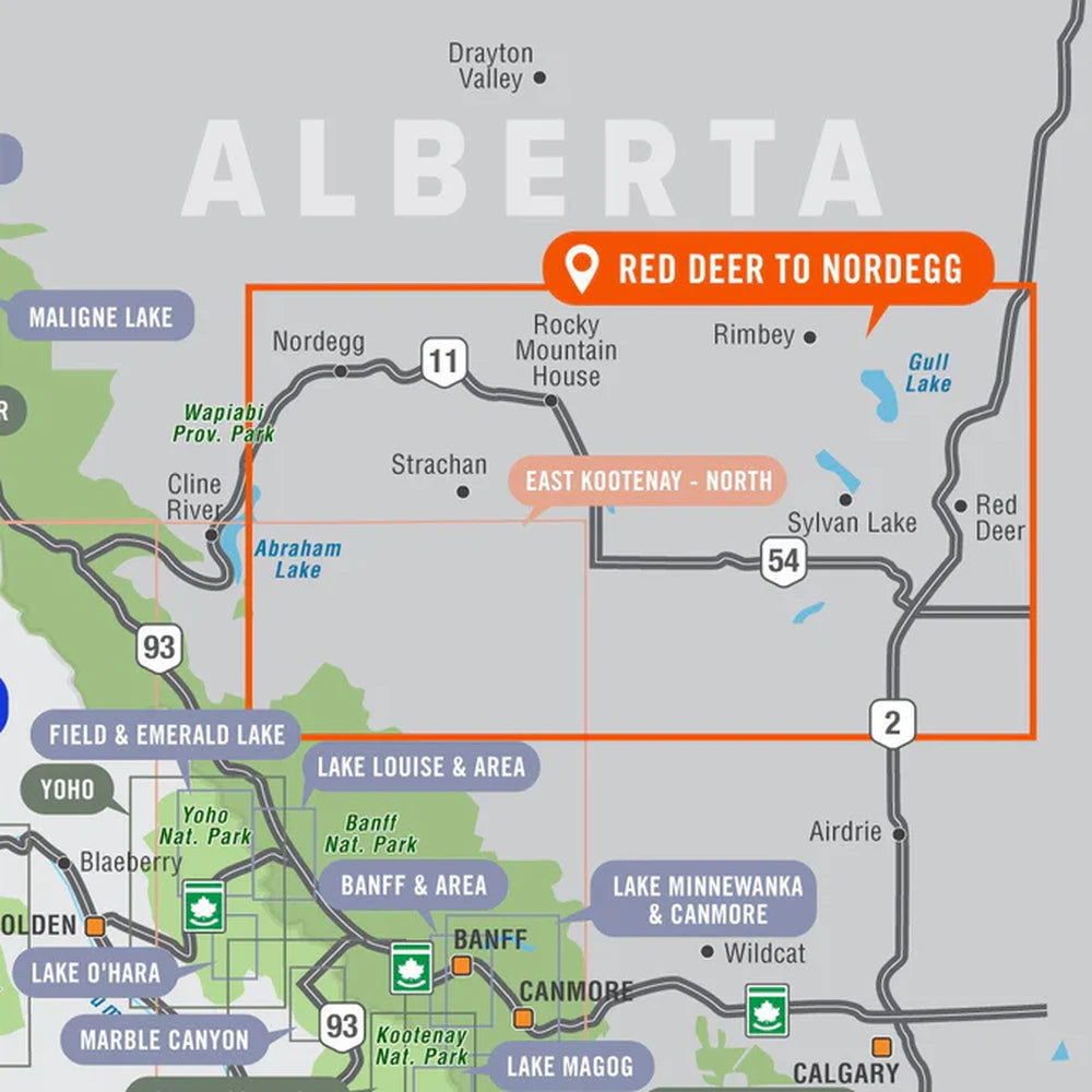
Red Deer to Nordegg Alberta Adventure Map
Central Alberta • Water-Resistant Map
This recreation topographic map for the Rocky Mountain Foothills around Rocky Mountain House and Red Deer highlights all the roads, fishing lakes & streams, front and backcountry campsites, paddling routes for canoeing and kayaking, wildlife viewing areas, multi-use trails for hiking, backcountry skiing, snowshoeing, mountain biking, horseback riding & more. Covering 1,950 km2 (753 mi2) using 1:50,000 scale water and road data, this map measures 38 x 51 km (24 x 32 mi), providing you with more topographic and recreational detail for the Nordegg to Lacombe and Olds area of Alberta than any other map on the market. Special features include private land and countless roads, trails and recreational Points of Interest. Included on this map are Red Deer, Rocky Mountain House, Caroline, Innisfail, Lacombe, Nordegg, Olds, Sundre, Sylvan Lake, Ya Ha Tinda Ranch and more!
The printed version of the map is displayed at 1:200,000 scale on 61 x 103 cm (24 x 40.5") paper. You can choose between having the map printed on regular water-resistant paper or a more durable waterproof synthetic. The Wall Maps have been customized to display nicely and fit into common picture frame sizes so you can hang them on the cabin, home or workshop wall. They are available in three different sizes and come printed on waterproof synthetic material.
Perfect For
Overlanding • Camping • Fishing • Hiking • ATVing • Paddling • Trip Planning
Discover Alberta’s Hidden Gems
From well-known lakes to remote backroads and trails, the Red Deer to Nordegg Adventure Map is your go-to resource for navigating and exploring Central Alberta’s foothills—helping you go farther, safer, and with more confidence.
Features
Features
Explore Alberta’s foothills like never before with the Red Deer to Nordegg Adventure Map—a highly detailed, field-ready map designed for navigation, trip planning, and discovering off-the-beaten-path adventures. Covering the region from Red Deer through Rocky Mountain House to Nordegg, this map delivers exceptional clarity and real-world usability for outdoor exploration.
Built with industry-leading cartography, it highlights everything from highways and logging roads to hidden trails, campsites, and recreation hotspots—making it an essential tool for both planning and navigating your next trip.
Print Features:
- Printed on regular water-resistant paper or durable waterproof and tear-resistant material
- Includes industry-leading cartographic detail and state-of-the-art relief shading
- Countless points of interest, hiking trails, campsites, boat launches, paddling routes and more!
- Easy to read, large-scale 61 x 103 cm (24 x 40.5") map at 1:200,000 scale
- Seamless map coverage requires no page turning
Why You'll Love This
Highly Detailed Topographic Mapping – Navigate with precision across roads, trails, and terrain
Complete Recreation Coverage – Includes hiking, paddling, fishing, camping, and more
Massive Area Coverage – Red Deer, Rocky Mountain House, Nordegg, Sundre, Ya Ha Tinda & beyond
Waterproof & Durable Options – Choose water-resistant paper or tear-proof synthetic material
Large, Easy-to-Read Format – No page flipping with seamless map coverage
Packed with Points of Interest – Trails, lakes, campgrounds, wildlife areas, and more
🏕️ Built for Central Alberta Exploration
This map focuses on one of Alberta’s most adventure-rich regions—the Rocky Mountain foothills along the David Thompson Highway (Highway 11), a corridor known for access to wilderness areas, rivers, and backcountry routes.
It covers approximately 1,950 km² of terrain, using high-resolution data for water features and road networks—providing more detail than most regional maps.
Specifications
Specifications
Map Scale: 1:200,000 (with detailed 1:50,000 data layers)
Coverage Area: ~1,950 km²
Area Covered
Red Deer, Rocky Mountain House, Caroline, Innisfail, Lacombe, Nordegg, Olds, Sundre, Sylvan Lake, Ya Ha Tinda Ranch, Clearwater River, Crimson Lake Park, Gull Lake, Kitsa/Wilson PLUZ, Ram Falls, Rocky Mountain Foothills, Alberta, Canada
Map Features
Highways, Logging Roads, Land & Water Features, Parks, Adventure Points of Interest, Campgrounds, Hiking Trails, Motorized Trails, Paddling Routes, Hunting & Fishing Areas, Winter Recreation and More.
Dimensions: ~61 x 103 cm (24" x 40.5")
Format: Folded map or wall map options
Material: Water-resistant paper or waterproof synthetic
Share
We clean up after ourselves.
Ecommerce deliveries have a carbon footprint. That's why we support verified projects that remove carbon from the air.
Every delivery’s carbon footprint is calculated based on weight, shipping method, and distance traveled. We neutralize these emissions by purchasing verified carbon removal credits from groundbreaking projects.
With your purchase, you’ll join a community of proactive merchants and customers dedicated to a sustainable future. Together, we've removed emissions for over 80 million deliveries and removed over 56 thousand tonnes of carbon.
We work with a network of pioneering carbon removal companies that have been vetted by the commerce platform Shopify.

